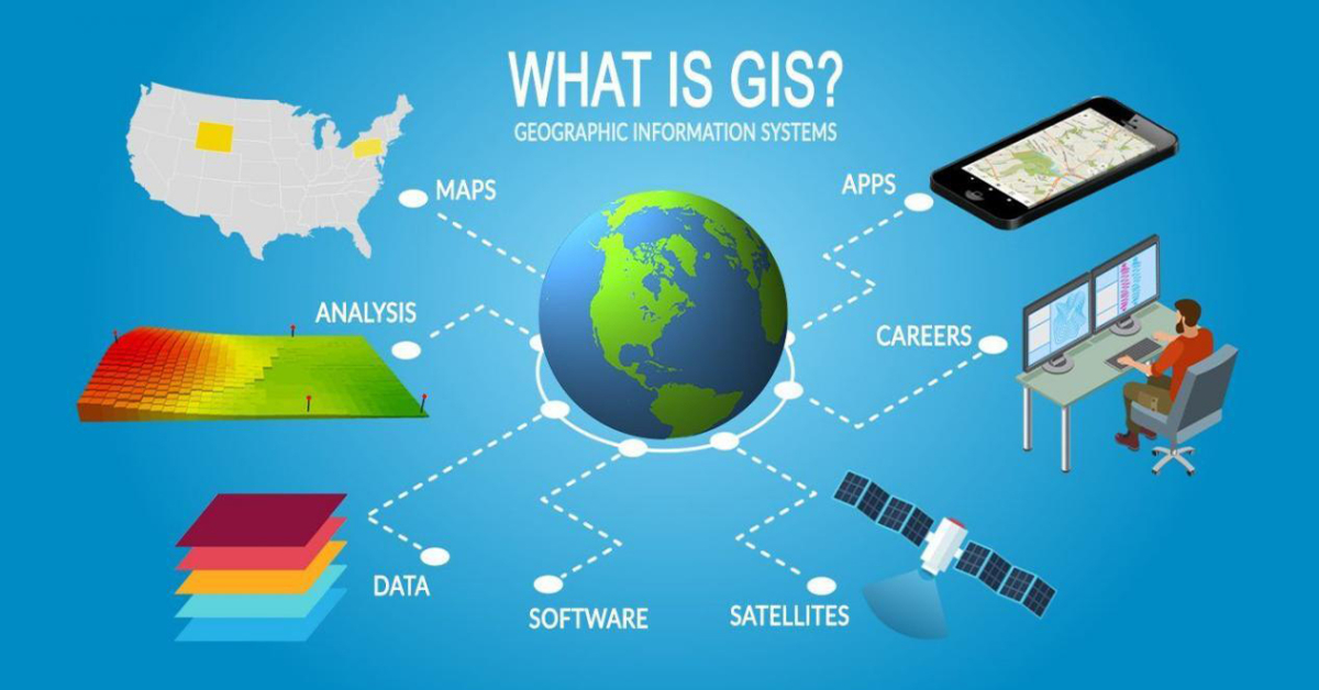

Welcome to the cutting-edge world of Geographic Information Systems (GIS)! At Venture Skill India, we recognize the immense power and potential of GIS software in revolutionizing the way we understand and interact with our dynamic planet. Whether you are a student, researcher, or educator, our GIS software offers a comprehensive suite of tools and resources to unlock the full potential of spatial data analysis.


Maximum
Average
Minimum
GIS technology provides a unique platform to visualize, analyze, and interpret geospatial data, enabling you to explore the intricate connections between people, places, and the environment. Our software combines powerful mapping capabilities with advanced data manipulation techniques, allowing you to create stunning maps, conduct in-depth spatial analysis, and make informed decisions based on real-world insights.
Through our GIS software, you can explore a wide range of applications, from environmental monitoring and urban planning to disaster management and market analysis. Our intuitive interface ensures that even those new to GIS can quickly grasp its concepts and harness its immense potential. With interactive tools and customizable workflows, you can delve into complex spatial relationships, extract meaningful patterns, and communicate your findings effectively.
At our educational institute, we are committed to empowering you with the knowledge and skills necessary to become proficient GIS users. Our comprehensive training programs and expert guidance will equip you with the tools and techniques to leverage GIS software effectively. Whether you're interested in pursuing a career in geography, environmental sciences, or any field that requires spatial analysis, our GIS software will be your invaluable companion on your academic journey.
Join us in embracing the power of GIS software and unlock a new realm of possibilities in understanding and managing our world. Explore, analyze, and visualize with our GIS software and discover the hidden connections that shape our planet's future. Together, let's transform the way we perceive and interact with our dynamic and ever-evolving world.
Welcome to the world of ArcGIS, the industry-leading Geographic Information System (GIS) software. At our educational institute, we are proud to offer you access to the most advanced and comprehensive GIS platform available today. With ArcGIS, you will enter a realm of spatial analysis and visualization, where you can unlock the power of geospatial data to understand our planet in new and exciting ways.
ArcGIS provides a user-friendly interface combined with a vast array of tools and capabilities to explore, analyze, and present spatial data effectively. Whether you are a student, researcher, or educator, ArcGIS empowers you to create stunning maps, perform complex spatial analysis, and gain valuable insights into our environment, society, and economy.
Our educational institute is dedicated to equipping you with the skills and knowledge needed to harness the full potential of ArcGIS. Through our comprehensive training programs and expert guidance, you will learn how to navigate the software, manipulate data, and employ advanced analytical techniques. Whether you are studying geography, environmental sciences, urban planning, or any other field that relies on spatial data, ArcGIS will be an invaluable tool in your academic journey.
Join us in embracing ArcGIS and revolutionize your understanding of the world around us. Explore, analyze, and visualize with ArcGIS, and embark on a transformative journey of spatial discovery.
Explore AutoCAD Map - your gateway to precision and innovation in mapping and geospatial analysis. Unleash the power of location-based data visualization, design, and collaboration like never before. Create, edit, and manage your maps with seamless integration, ensuring accuracy and efficiency in every project. Elevate your mapping experience with AutoCAD Map and revolutionize the way you navigate the world of design.
Discover the potential of AutoCAD Civil 3D - your gateway to mastering civil engineering design and documentation. Join Venture Skill India to unlock the power of this industry-leading software, designed to streamline your workflow, enhance collaboration, and optimize project outcomes. From conceptualization to construction, our comprehensive training empowers you to create, analyze, and visualize civil infrastructure in innovative ways. Elevate your skill set with AutoCAD Civil 3D through Venture Skill India and shape the future of infrastructure development.

"Studying GIS through Venture Skill India has been a game-changer for me. The course was comprehensive and well-structured, covering everything from basic concepts to advanced applications. The hands-on projects gave me the practical experience I needed to confidently work with geospatial data."
"Enrolling in the GIS program with Venture Skill India was a decision that transformed my career path. The curriculum was not only informative but also engaging, with a perfect balance between theory and hands-on experience. The practical projects challenged me to think critically and creatively, enhancing my problem-solving skills. "
"Embarking on the GIS journey with Venture Skill India has been a revelation. The program exceeded my expectations in every way. The instructors were not just teachers, but mentors who guided me through the intricacies of geospatial analysis. "
"Venture Skill India's GIS program has been a game-changer for me. The depth of knowledge I gained and the practical skills I acquired have given me an edge in the competitive world of geospatial technology. The course structure was well-thought-out, and the hands-on exercises were both challenging and rewarding."